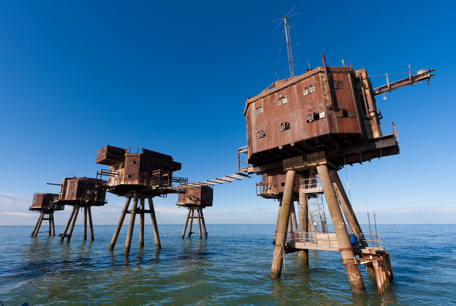
The Red Sands towers stand above the Thames Estuary on narrow legs. Their strange silhouette makes more sense when you read them as a defensive group designed to be assembled offshore.
From a boat, the Red Sands sea forts look like a group of small buildings lifted clear of the water. Each steel box stands on narrow legs, with open sea where streets and foundations would normally be. The gaps between the towers make the group as recognizable as the towers themselves.
These are part of the Maunsell sea-fort story, named for engineer Guy Maunsell. Red Sands was an Army fort in the Thames Estuary. It should not be confused with every other structure carrying the Maunsell name, or with the separate naval fort associated with Sealand.
A defensive battery moved into the estuary
Project Redsand's history explains the wartime problem: aircraft threatened shipping in the Thames approaches, including through mine-laying. Offshore defenses extended the area that anti-aircraft guns could cover. The water made an ordinary land battery impossible, so the engineering had to move the working platform above it.
The Army design used seven towers linked by catwalks. The towers were constructed on land, taken downriver and placed offshore. Their arrangement distributed the functions of a defensive position across a group rather than compressing everything into one large floating-looking platform.
The Fortress Study Group's account connects the group to the layout of land-based heavy anti-aircraft sites and distinguishes Maunsell's Army and Navy designs. It is a useful corrective to the impression that the towers were simply an eccentric experiment. Their unusual form answered a specific operational need.
The spaces between the towers matter
Look at the relationship between each box and its supports. The large upper volumes appear almost top-heavy from the water, yet the legs leave the estuary visually continuous beneath them. Walkways once made the dispersed group function as a connected workplace.
The reference photograph accompanying this article dates from August 2011. It includes a foreground tower with an access ladder and portions of historical connecting walkways. Those details belong to that image's date. They are not instructions for boarding, and the photograph does not establish which walkways survive or are usable today.
Changing viewpoints from a boat reveal why the towers can seem to crowd together in one image and spread far apart in another. Their arrangement is three-dimensional. A single telephoto view may compress the gaps and disguise the size of the group.
After the guns
The forts acquired new uses after the war, including pirate radio. Project Redsand identifies Radio 390 with Red Sands and distinguishes other stations operating from other forts. That history adds another layer to the silhouette: the structures later carried broadcasting equipment as well as their original military role.
Today, Project Redsand describes its conservation aims. Work on access systems and preservation should not be mistaken for an unrestricted public museum. A restoration project's aspirations and a visitor's booked permission are different things.
This article treats a boat view as the verified visitor option. No routine landing or interior tour was confirmed in the sources reviewed on October 16, 2026. If a future provider offers one, ask exactly which tower is included and under whose authorization before treating it as an established product.
Choose a named boat trip
Whitstable Boat Trips' Red Sands product describes a departure from Whitstable Harbour, travel toward the forts and time for photographs from the water. Its page listed £40 per person when checked. The operator's main overview describes the standard trip as approximately an hour; other, longer fort itineraries are separate products.
Check the actual departure calendar, vessel, boarding requirements and weather policy before making a special journey. An offshore trip depends on operating conditions, and no fare or departure is guaranteed by this article. Ask about accessibility, minimum ages and suitability if those details affect your group.
The photographic reward is the group in its setting: legs, boxes, gaps and moving water. Seeing the towers offshore also restores the logic that a close crop removes. The distance from land was fundamental to their defensive purpose, and it remains fundamental to how they can be visited.
Follow the thread
Denkort Bunker Valentin preserves another wartime structure after its intended military function ended, but its interpretation centers the forced labor that built it.
At Petrova Gora Monument, damaged cladding also demands a dated reading, with a memorial's purpose remaining essential to understanding its unusual shape.
Sources and reporting
Researched October 16, 2026, from the linked sources. This is desk reporting; no firsthand visit is claimed.
- ProjectRedsand Army history
- FortressStudyGroup project account
- ProjectRedsand mission
- WhitstableBoatTrips RedSands product
- WhitstableBoatTrips overview
The reference photograph