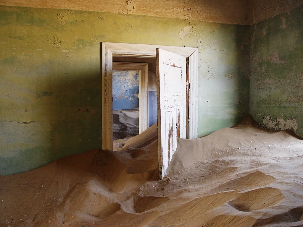
A white door still hangs open in Damien du Toit’s 2006 photograph of Kolmanskop. Beyond it, several doorframes line up through a house; the rooms are separated by walls but joined by sand. Green plaster in front and blue paint farther back make the domestic scale unmistakable. These were rooms arranged for people before they became a recognizable desert image.
Kolmanskop, near Lüderitz in Namibia, developed around diamond mining. Today it has an organized visitor operation, Ghost Town Tours. The name “ghost town” describes its changed settlement history; it doesn’t mean unrestricted entry to every house or an invitation to arrive without checking the access arrangements.
Begin with the settlement, not the dune
The site operator connects the town’s formation with the discovery of diamonds in 1908. The surviving buildings belong to that mining settlement. This is enough to establish the basic economic reason for the town without turning its short prosperity into a story about an empty desert suddenly acquiring history.
A useful question for any mining town is what had to be supplied alongside the mineral itself. Housing, food, water, transport and ordinary services belong to the same story as extraction. Look at a room as part of a settlement that had to operate, rather than as an isolated backdrop. A door was once a practical boundary between spaces with different uses.
The source photograph gives a particularly clear example. There is a ceiling, painted plaster and a door with panels and trim. Those details make it possible to read the room as a designed interior. Sand has entered that arrangement; it hasn’t erased all of it.
Whose rooms survive in the familiar view?
Nicola Alexander’s 2010 University of Cape Town study describes a hierarchy: management villas on the upper slopes, artisans’ housing below, and segregated workers’ quarters beyond the tourist boundary. Her research drew on interviews as well as historical and site analysis. She found that the familiar account favored the elite residential area while underplaying social and technological history. The sand-filled house is one part of that unequal settlement. Her description records 2010 conditions; it establishes no present permission to visit the compounds.
Look closer: three frames, one continuous surface
Start at the nearest doorframe. Its lower edge is partly swallowed by a drift. Then follow the next opening toward the blue wall. Sand crosses the thresholds, while the remaining trim preserves a sequence of rooms.
The photograph sets up two different geometries. The house uses rectangles and straight edges to divide space. The sand forms slopes that ignore those divisions. You can see both without needing a staged object, a figure in a costume or a newly opened passage. The most revealing feature is the surviving relationship between the rooms.
The image was taken on July 14, 2006. It cannot tell you where the sand sits now, whether this particular doorway remains passable or whether the room is on the currently permitted route. A photograph that is easy to recognize can still be a poor set of directions.
A photographed place has another history
Kolmanskop also appears in museum collections as a subject of art photography. The Smithsonian’s Family Accommodation / Portfolio Kolmanskop records a work centered on a sand-filled domestic interior. Its collection entry is evidence about that artwork and the way the settlement has been represented, not a visitor map.
That difference is useful when reading travel images. A photographer chooses a room, an angle and a moment. The resulting picture can become more familiar than the town’s layout or its economic history. Ask what the frame allows you to understand and what sits outside it: neighboring structures, visitor management, labor and the wider landscape.
Choose the access product before the light
Ghost Town Tours publishes a tours and prices page. That page did not load reliably in this research session, so this article does not quote a current permit price, a departure time or permission to enter for sunrise. A search excerpt and another traveler’s permit are not enough to establish the terms of your visit.
What is established is the operator identity: the Namibia tourism directory lists Ghost Town Tours at Kolmanskop. Use the operator’s current information to settle the date, admission type, allowed hours and any professional photography requirements before arranging transport. Keep confirmation with the rest of the trip details.
A normal sightseeing visit and a photography arrangement may involve different permissions. Don’t assume that buying one includes the other. Equally, a failure to open an online page here does not mean tickets are sold out or the attraction has closed.
Use the map for orientation
The operator provides a directional map page. Use that as the starting point for the current arrival plan rather than the geotag of a photograph. A camera coordinate identifies where a picture was made; it is not necessarily a gate, a safe parking space or a permitted approach.
For the visit itself, our recommendation is to understand a building’s role before looking for the most familiar doorway. Follow the operator’s instructions about rooms and surfaces. Respect any closed section even if an older photograph shows someone inside it. The appeal of these interiors comes partly from their fragility, which is a reason to keep to the visitor arrangement.
Kolmanskop rewards a second look at the house beneath the sand. The dune is the feature people recognize; the door explains what changed.
Real reference: Damien du Toit, July 14, 2006, CC BY 2.0, via Wikimedia Commons. Current room access and sand levels are unverified.
Follow the thread
Al Madam Buried Village also places sand inside a settlement's story, but its modern housing origins differ sharply from Kolmanskop's diamond economy.
At Humberstone Saltpeter Works, surviving homes and services reveal the everyday settlement built around another extractive industry, nitrate production.
The reference photograph