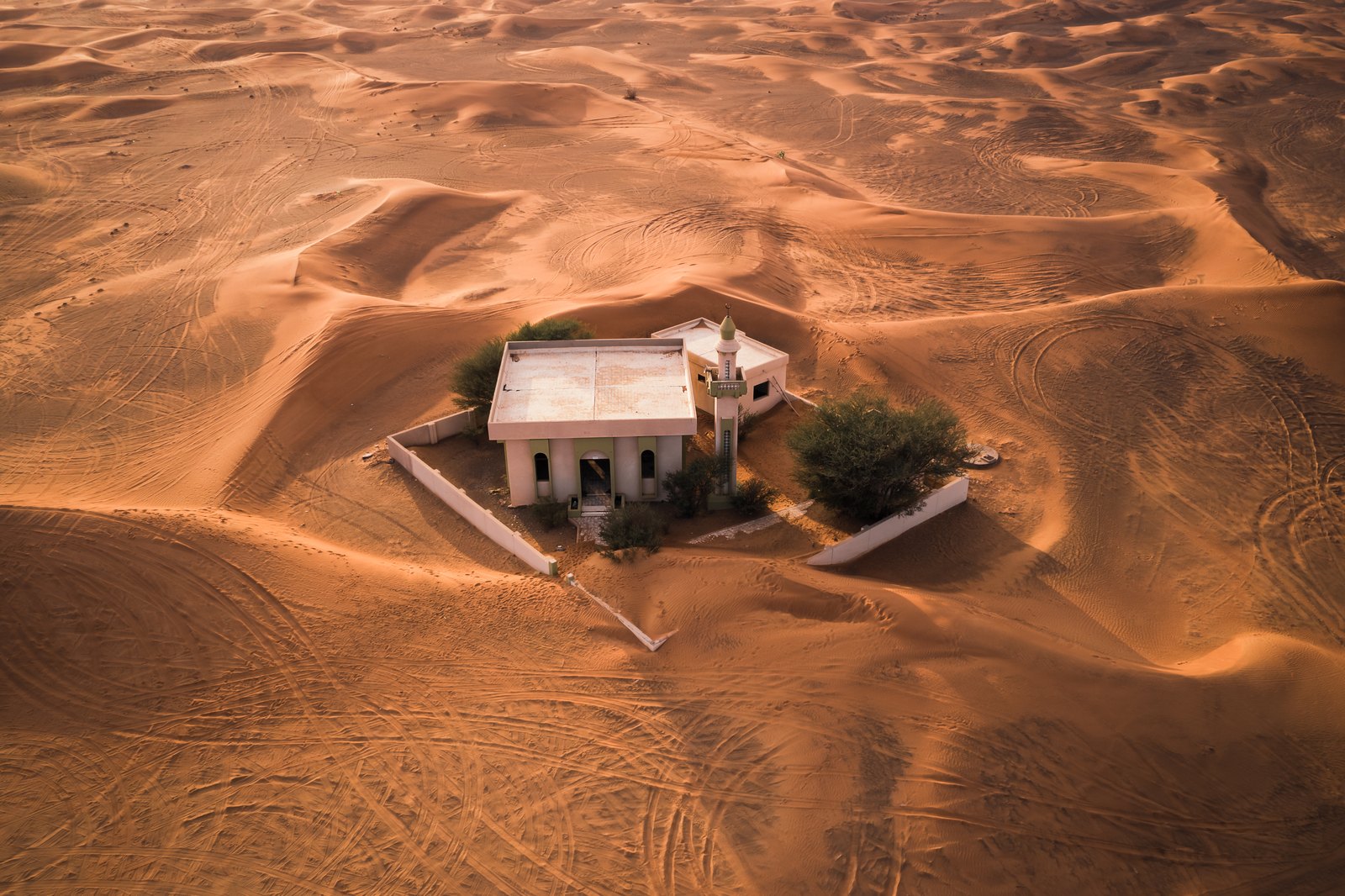
The mosque in the aerial photograph of Al Madam has a flat white roof, a veranda and a low compound wall. Dunes surround it, but the architecture belongs to the modern United Arab Emirates. That is the important first correction to the familiar “lost village” description: this is a recent settlement with a history of housing policy, movement and daily life.
The Buried Village is in Sharjah’s Al Madam area. Its houses have become a subject for photographers and architects. Current entry arrangements were not established in this research, so this is a story about the place and how to read its images, rather than a confirmed driving itinerary.
Houses designed for a new way of living
Sharjah’s tourism authority places the village within a public housing program after the formation of the UAE in 1971. It describes residents who had previously followed a semi-nomadic way of life. Its explanation for their eventual departure includes desert conditions and long commutes; it presents these as the commonly understood account rather than a documented explanation from every household.
That distinction leaves room for a more useful question than whether the village is haunted. What does a permanent house ask of people whose routines once depended on movement? A roof, a fixed address and a defined plot offer one kind of stability. Access to work and the practical demands of the surrounding environment remain separate questions.
The buildings can help make that question concrete, but they cannot answer it alone. An empty room does not tell you what a family thought about living there. The presence of sand does not identify the exact day or reason someone left. Treat the architecture as a record of a plan, and personal experience as something that requires testimony.
Look closer at the compound
In the photograph, the mosque sits within a low perimeter. The roof and veranda define a compact enclosure, while ridges and tracks extend through the sand outside. The viewpoint shows the relationship between a fixed structure and a changing surface particularly clearly.
Read the perimeter before the dune. A wall marks an intended boundary even where sand now crosses or covers it. Then follow the roofline: straight edges and repeated openings make the original arrangement visible. The fixed lines of the building make the changing sand easier to read.
The aerial view is not a map of the entire village, and its aerial viewpoint is not a publicly accessible lookout. Its date also matters: the shape and depth of a dune are conditions of that particular image.
An art project asked what preservation means
The Sharjah Architecture Triennial’s Concrete Tent project, by DAAR — Sandi Hilal and Alessandro Petti — used Al Madam as a setting for an experiment in preservation. Its account describes a reused timber frame, a concrete-like finish and jute applied around one modernist building. The project belonged to the triennial held from November 2023 to March 2024.
This adds another layer to the village’s visual history. A building that first expressed permanence became the subject of an intervention about temporary and unsettled conditions. The artists’ interpretation is worth considering as an interpretation. It is not a substitute for the former residents’ own accounts, and the project page does not establish that the installation remains intact or accessible today.
There are several possible things to preserve here: material, a building plan, a memory, a photograph or the account of an experiment. They are related, but they are not interchangeable. Repairing a wall can protect a structure while altering the appearance that made an older photograph recognizable. Recording change may be as revealing as searching for a timeless view.
What a photograph cannot authorize
The official Arabic account also describes the abandoned village, but neither language version supplies a reliable date-specific entry record for this article. We have not verified a public gate, a permitted off-road approach, an admission fee or permission to enter the mosque and houses.
If you intend to go, settle those points with current local visitor information before setting out. Keep the last approach distinct from the paved journey to Al Madam town. A marker shared by a photographer does not establish a legal or suitable driving route, and an image of an empty interior does not authorize access to it.
The remaining uncertainty narrows the travel promise; it doesn’t remove the story. Al Madam is revealing because its buildings belong to living regional history. Look at the straight roofline within the dunes and a more specific question appears: what happens when the place built to keep people settled is the part that stays behind?
Follow the thread
Kolmanskop also places sand within domestic architecture, but its diamond-mining economy gives the settlement a very different history.
Al Jazirah Al Hamra follows another Emirati settlement through coral-stone buildings and conservation, with pearling and coastal trade central to its past.
The reference photograph