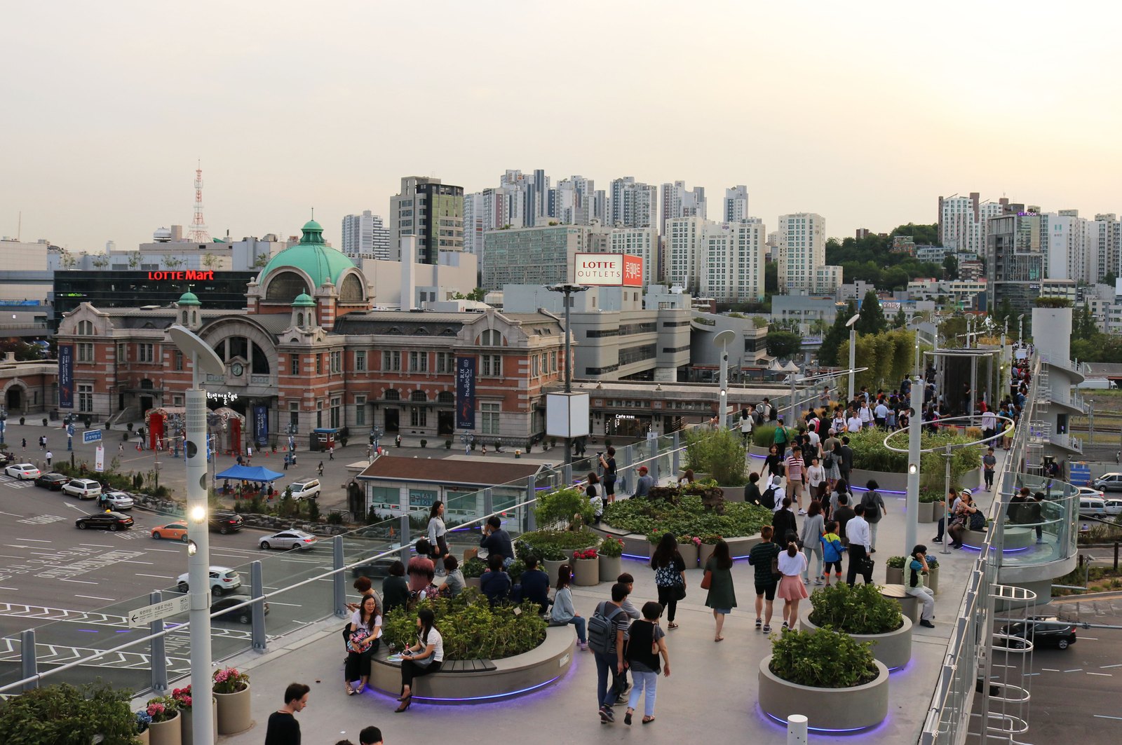
In the selected photograph of Seoullo 7017, people weave between round planters above a busy part of Seoul. The red-brick former station building and its green dome sit to one side; taller blocks fill the distance. The walkway makes the city visible at a level once reserved for traffic.
Seoullo is a converted road overpass beside Seoul Station, now a planted pedestrian route. Its name joins the original road’s 1970 date with its 2017 public-garden transformation. It works best as a connection with somewhere to go, rather than a park you have to complete from one prescribed entrance.
Plan an entrance and an exit
The Seoul tourism page, checked October 16, 2026, lists free admission and 24-hour opening. The national tourism listing describes its connection to Seoul Station and also lists the public walkway as free and open around the clock.
These are general operating descriptions. A particular elevator or stairway may have its own status, so choose a current access point if stairs would affect your visit. An address pin for the whole linear park is not the same thing as the entrance most useful for your next destination.
Our recommendation is to decide where you want to descend before you start. A walk toward a neighborhood, a station connection or a return to the same side of the railway are different plans. The route can be a useful part of moving through Seoul, not an extra circuit added to an already crowded itinerary.
The road structure stayed in the picture
The architect, MVRDV, describes adapting the elevated steel-and-concrete road structure into a planted public route. Its planting concept groups Korean species as a kind of walkable collection. New links connect the viaduct with the surrounding city.
That is a different proposition from building a garden on unoccupied ground. A road provides a long surface, a certain height and a fixed relationship with the streets below. The conversion has to work with that inherited shape. The linear form helps explain why connections and descent points are central to the experience.
Look down as well as outward. Where a path crosses a road or railway, the separation of levels becomes visible. An obstacle at street level becomes something a person can cross above. That does not automatically make every journey shorter; it gives the pedestrian network another option.
Look closer at the circles
The real reference shows repeated circular concrete planters set within the walkway. Their sizes differ, and people pass through the spaces between them. Railings define the outer edge; buildings and transport infrastructure remain visible beyond.
Follow one line through the photograph. The planters interrupt a straight visual corridor, while the overall structure still carries people along a clear direction. The design asks the same strip of space to accommodate both movement and stopping. That relationship is easier to see in a wide frame than in a close-up of foliage.
The photograph also keeps the city in view. Plants do not make the traffic, station or skyline disappear. That is part of the interest: the new use sits within the old transport setting instead of pretending to be somewhere else.
A garden that changes with time
The architect’s account describes planting intended to change through the seasons and develop as it grows. Treat that as a design intention rather than a guarantee that every species, arrangement or promised future connection survives unchanged. A photograph from the opening period and one taken years later may show different amounts of foliage without either being misleading.
An MVRDV opening-period update, dated June 2017, records the park’s public opening that May. Its visitor figures belong to that early period. They do not measure how busy the walkway is on a particular day now, or prove how every nearby business has benefited.
For a visit, choose the daylight and weather you prefer rather than a supposed universal “best time.” Our suggestion is daylight for understanding the relationship with the station and streets. If you go after dark, regard any older photograph of colored lighting as a dated example, not a promised display.
Get the scale right
The route is roughly a kilometer long and sits about 16 meters above the street, according to the architect. The height brings the moving traffic below into a different relationship with a person walking above it.
There is no single tour duration to quote. Walking time depends on where you enter, where you leave and how often you stop. Use the city park information for current facilities and the map for access, then keep your own pace.
Seoullo’s most useful transformation is visible when somebody uses it to get somewhere. The planters invite a pause, but the old road’s line continues to do work: it carries a different kind of traffic across the city.
Follow the thread
Oil Tank Culture Park gives another formerly restricted part of Seoul's infrastructure a public landscape, while preserving different kinds of industrial containers.
Lingotto rooftop / La Pista 500 also replaces vehicle movement with pedestrian use, keeping a rooftop test track's banked curves around its garden.
The reference photograph